Sale on canvas prints! Use code ABCXYZ at checkout for a special discount!

Boundary: Bleed area may not be visible.


by Texas Map Store
$22.95
Size
Bottom Style
Image Size
Product Details
Dress it up, dress it down, or use it to stay organized while you're on the go. Our zip pouches can do it all. They're crafted with 100% poly-poplin fabric, double-stitched at the seams for extra durability, and include a durable metal zipper for securing your valuables.
Our zip pouches are available in three different sizes and with two different bottom styles: regular and t-bottom.
Design Details
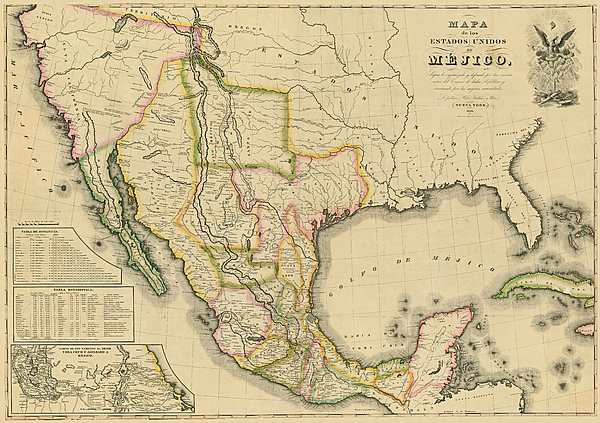
This map, in Spanish, covers the entirety of Mexico as it was in 1828 including what is now Texas, New Mexico, and California. It shows rivers,... more
Care Instructions
Spot clean or dry clean only.
Ships Within
2 - 3 business days
This map, in Spanish, covers the entirety of Mexico as it was in 1828 including what is now Texas, New Mexico, and California. It shows rivers, lakes, mountainous areas, mines, cities, towns, missions, forts, and Indian tribes, ruins, and villages. It features an inset map, 'Carta de los Caminos & c. desde Vera Cruz y Alvardo a Mejico (Map of the Roads and etc. from Vera Cruz and Alvardo to Mexico City)' as well as two tables: 1) Tabla de Distancias, 2) Tabla Estadistica (Statistics).
$22.95


There are no comments for Mapa de los Estados Unidos de Mejico 1828. Click here to post the first comment.