Sale on canvas prints! Use code ABCXYZ at checkout for a special discount!

Boundary: Bleed area may not be visible.


by Texas Map Store
$22.00
Size
Bottom Style
Image Size
Background Color
Product Details
Dress it up, dress it down, or use it to stay organized while you're on the go. Our zip pouches can do it all. They're crafted with 100% poly-poplin fabric, double-stitched at the seams for extra durability, and include a durable metal zipper for securing your valuables.
Our zip pouches are available in three different sizes and with two different bottom styles: regular and t-bottom.
Design Details
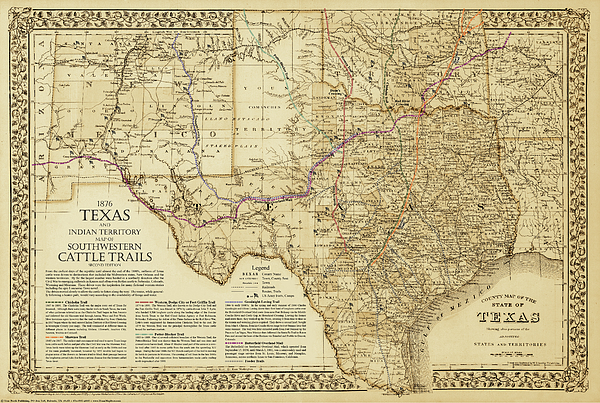
An exclusive design featuring a stunning 1876 S.A Mitchell map of Texas, Indian Territory and New Mexico overlaid with the established routes of the... more
Care Instructions
Spot clean or dry clean only.
Ships Within
2 - 3 business days
An exclusive design featuring a stunning 1876 S.A Mitchell map of Texas, Indian Territory and New Mexico overlaid with the established routes of the Chisholm, Great Eastern, Great Western or Dodge City, Goodnight-Loving & Shawnee cattle trails, the Butterfield Overland Stage Line, the very few early Texas railroads, and the locations of most the Frontier Forts plus other detail
$22.00


There are no comments for 1876 Great Texas and Southwestern Cattle Trails Map. Click here to post the first comment.